|
|
History of Bay RidgeFrom The Peopling of New York City
The Battle of Brooklyn (1776)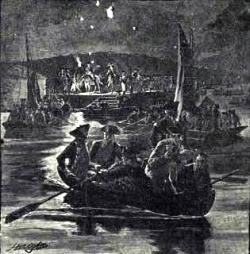 On August 26th 1776, General William Howe landed at Denyse Pier* and marched 34,000 British troops up Shore Road.** They turned right at Owl’s Head Park*** and traveled up 3rd Ave to meet George Washington and his troops stationed near what is now Greenwood Cemetery. On the morning of the 27th, the British troops opened fire on the unsuspecting American soldiers. The 10,000 poorly prepared and armed American forces stood no chance against the British. The American faction broke up into small groups of 200-300 (in some instances) to charge enemy lines in attempts to break morale, but these attempts failed miserably. By the end of the battle, the Americans lost about 1,400 soldiers while the British lost approximately 400, a crippling loss for Washington. During the night of August 29th and 30th, 1776, having officially lost the battle, the Americans decided to flee Long Island for Manhattan. In a stroke of genius, General George Washington proceeded to organize one of the greatest retreats in American history. His plan was to take all of his forces across the East River in the dead of night, to avoid more unnecessary casualties. Their plan almost fell through, because General Howe’s brother, Admiral Howe was sailing down the East River while he marched on the ground, in an attempt to close off Washington by land and sea. The flight was a risky choice, because if their retreat was not completed by dawn, the move would put the American troops in full range of the British naval fire, which would end the war. This is exactly what happened and the retreat wasn’t finished by sunup, but thanks to two miraculous factors, the American soldiers survived decimation. General Howe’s march was delayed by a British-American conspirator, which set him back by a day. This however, could not stop Admiral Howe’s descent by the sea. The 88 frigates would have come across the American fleet ere break of dawn if not for a dense fog which fell across Long Island. This mysterious event allowed more then 9,000 American troops, along with artillery, to cross the East River unharmed. This move stunned the British and allowed Washington to move on to win the Revolutionary War.
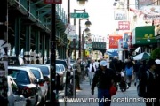
The First Steam Engine Engines (1864-1876)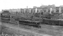 In the 1860s, the superintendent of a street survey commented on how the areas of rural Kings County (including Bay Ridge) were still underpopulated due to the lack of transportation. “Through this whole area there is no direct steam railway communication with New York; no way in which, with regularity, frequency, comfort and speed, a business man can be carried to and from the city, as he can be carried in any other direction; and in consequence of this an acre of building lots in the rocks or swamps or Harlem, six or seven miles from the Battery, is worth twenty-five times as much to-day as an acre in Kings County no further away!” -Samuel McElroy The first trains which traveled through Bay Ridge in 1864 were on the Brooklyn, Bath and Coney Island Railroad, which began near Greenwood Cemetery and went straight through to Coney Island, were a byproduct of the urban masses that wanted quick transportation to the beach. Soon after, many other railroads began to follow suit, with the opening of the Brooklyn and Rockaway Beach Railroad in 1865, which opened in order to make a connection to the ferry that led to a beach resort across Jamaica Bay. Based on the popularity of these two railroads, more began to sprout into existence throughout Kings County and Bay Ridge. This included the Brooklyn, Flatbush, and Coney Island Railway in 1878, which was a consolidation of the former Flatbush, Coney Island, Park and Concourse Railroad* and the Coney Island and East River Railroad**. These railroads began to gain so much popularity that they literally consumed what was once rural Bay Ridge. Brooklyn eventually became known as "The Great Railroad Hub!"[1], which forced many of the old Dutch farmers who inhabited Bay Ridge to pack up and leave. This was the monumental change which turned the small farms in the township of New Utrecht into the bustling city it is today.* Opened in 1877. ** Opened in 1876. The R Train (1916) Lui Masu: "Bay Ridge is a New Neighborhood"* * Luigi Masu is President of Vietnam Veterans of America chapter 72, Brooklyn, NY. The Verrazano-Narrows Bridge (1964-1969)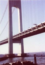 It’s virtually impossible to look at Bay Ridge without mentioning the Verrazano-Narrows Bridge [2] , the largest suspension bridge in the United States. The Verrazano Bridge (as it’s most commonly referred to) was built in five years, spanning from 1959 to 1964. It marked a significant turning point in Bay Ridge, since it made Staten Island accessible without the need for boats or tedious ferry rides. Thus, the bridge eliminated the Narrows Strait as a barrier between the boroughs. Also, with the mass production of automobiles that took place in 1914 it was essential to build a route that would allow for greater mobility. Robert Moses oversaw the construction of the bridge, while Chief Engineer Othmar Ammann designed it.  Saturday Night Fever (1977)Saturday Night Fever is a film that defined Disco as well as Bay Ridge. The film, starring John Travolta as Tony Manero, showcased aspects of the music, the dancing, and the subculture surrounding the disco era, which had never been done before. It displayed symphony-orchestrated melodies done by the Bee Gees, haute-couture styles of clothing, sexual promiscuity, and graceful choreography. The story was based upon a 1976 New York magazine article by the British writer Nik Cohn, titled "Tribal Rites of the New Saturday Night." A newcomer to the United States and a stranger to the disco, Cohn was unable to make heads or tales of the subculture he had been assigned to write about. The characters who were to become Tony Manero and his friends sprang almost completely from his imagination. In the late-1990s, Cohn acknowledged that the article had been fabricated. In the movie, Tony Manero is a troubled Brooklyn adolescent whose life revolves around the local discothèque. His visits to the disco help him to temporarily forget about the realities of his life, his dead-end job, his clashes with his unsupportive parents, his racial tensions in the local community, and his associations with his dead-beat friends. The film made Travolta’s career, as well as the Bee Gees, and is notable for being one of the first instances of cross-media marketing, with the tie-in soundtrack's single being used to help promote the film before its release, and vice versa after the movie’s debut.
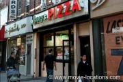
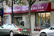 The hardware store where Tony works, and to which he's carrying the bucket of paint, is Bay Ridge Home Center (7305 Fifth Avenue at 73rd Street). It's been renovated and re-sold, but is still a hardware store. -->
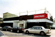
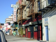 Two locations which no longer stand are the White Castle, patronized by Tony and his friends, which stood on 92nd Street between Third and Fourth Avenues in Bay Ridge, and the coffee shop which Tony and Stephanie visit. It's now a Mazda car dealership on Fifth Avenue at 94th Street. You can still visit Kelly's Tavern, 9259 Fourth Avenue, past which the couple walk afterwards. -->
Bay Ridge Tornado (Aug 9, 2007)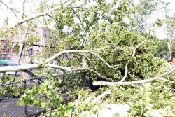 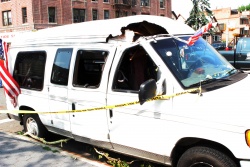 
Bay Ridge Today
Lui Masu and the Revolutionary War Cemetery* Lui Masu on the 9/11 Memorial at the 69th Street Pier* The Freedom Tree on Shore Road* * Luigi Masu is President of Vietnam Veterans of America chapter 72, Brooklyn, NY. Maps of Bay Ridge (1800's-today)Some maps of Bay Ridge from the past to the contemporary[4] 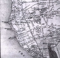 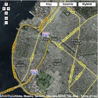 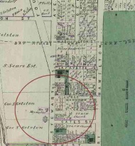
|