Views
Contents |
Jamaica Hills Back in the Day
Colonial Times:Back when it was "Jamaica Town"
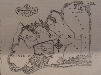
| Queens County in 1683[1] |
|---|
Jamaica Hills is located in an area which Native Americans called “Ahmeco” or “Yameco” more than three hundred years ago. The area was named for the beavers who inhabited the ponds and creeks of what would later be known as Jamaica. [2]
Jamaica Hills was once a part of the Town of Jamaica, which was founded in 1656 through a grant of Governor Stuyvesant. [2] The town was bounded to the west by what is now the Brooklyn-Queens border, on the East by New York City-Nassau Country border, on the sound it included Jamaica Bay, but not the Rockaways, and on the north it was bounded by a hilly terrain. [1] Today this hilly terrain is the area near Grand Central Parkway. Therefore, Jamaica Hills was on the northern part of Jamaica Town. In 1683 Jamaica Town became a part of Queens County, which was established by the act of the General Assembly of the Province of New York. [1]
The first settlers of Jamaica, after the Native Americans, were the English even though the area was controlled by the Dutch. [2] Even though a grant was signed in 1655 for the area, the area was not officially given a name. [1] The Dutch called the area Rusdrop and thr English later called it Crawford. [3] Neither name was popular, so in 1680 the name Jamaica was adopted [4] A deed of Jamaica from the Native Americans shows that Jamaica's first settlers were fishermen and farmers from Hempstead. [3]
Nineteeth Century
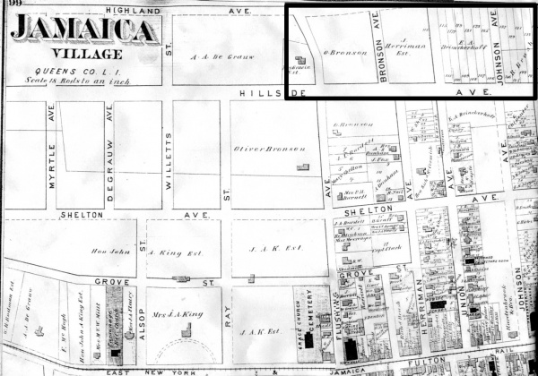
| Jamaica Village (1873): Southern part of Jamaica Hills was a part of Jamaica Village. Note that Flushing Avenue is known today as Parsons Blvd. To view the entire map click here |
|---|
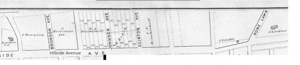
| Jamaica Hills portion from the map above (taken from the full map). [5] |
|---|
References
- ↑ 1.0 1.1 1.2 1.3 1.4 1.5 Wilson, John E. "Historic Central Queens: A Brief History of Jamaica and Surrounding Communities". Queens Civic Record. April 1939, pg 21. History of Jamaica. Volume 1. Queens Borough Central Library Long Island Division.
- ↑ 2.0 2.1 2.2 Wilson, John E. "Historic Central Queens: Jamaica and the Beaver". Queens Civic Record. April 1939, pg 21. History of Jamaica. Volume 1. Queens Borough Central Library Long Island Division.
- ↑ 3.0 3.1 Sherwin, Mark. "Jamaica Owes Name to Indians' Beaver". Daily News. 9 Feb 1936. History of Jamaica. Volume 1. Queens Borough Central Library Long Island Division.
- ↑ "Community and Library History". Queens Borough Public Library. [1]
- ↑ "1873 Beers Map of Jamaica Village, Queens, New York City" Geographicus Fine Antique Maps. Map.