From A Neighborhood in Transition
The Morningside Heights area is bounded by 125th Street to the north, 110 Street to the south, Morningside Avenue to the east, and the Riverside park to the west. The street network is more of a regular grid. The main north and south corridors are Broadway, Amsterdam Avenue, Frederick Douglass Boulevard, while 125th Street and 116th Street are the main east and west arteries that service Morningside Heights. Morningside Heights is connected to major highways and public transit. The major expressways in the immediate vicinity are the Harlem River Drive, FDR Drive and Henry Hudson Parkway. The major public transit operator providing service in the area is MTA New York City Transit.
Contents |
Means of Transportation
Subway Service
The Metropolitan Transportation Authority (MTA) operates in the Morningside Heights area. Five subway lines serves the area along six stations. These subway lines connect the neighborhood to the Bronx and to the rest of Manhattan. All stations were designed accordingly to the NYCT (New York City Transit) Station Planning and Design Guidelines with capacities for stairs, escalators, turnstiles, fare control turnstiles and agent controlled service gates. All stations usually maintain free flowing conditions without pedestrian conflicts even during peak hours.
| Lines | Routes | Stations |
(Local) | Broadway | West 116th St. West 125th St. West 137th St. |
(Local) | Frederick Douglass Blvd./St. Nicholas Avenue | West 116th St. West 125th St. |
(Express) | Frederick Douglass Blvd./St. Nicholas Avenue | West 125th St. |
116th St and Broadway (1)
The station was designed with one central fare control area for both uptown and downtown service. It provides service to the 1 subway line, both downtown and uptown service. Access to the subway station is possible through the northwest and northeast corners of West 116th St. There is a high-wheel turnstile located at the southern end of the uptown platform allowing passengers to exit the station at the northeast corner of West 115th St. Another high-wheel exit-only turnstile was added near the downtown stairs at the northeast corner.

125th and Broadway (1)
The 125th St station is an elevated station and the fare control area is under the platforms of the station, located at the intersection of 125th and Broadway. The station can be accessed from one stairway located at the southeast corner of West 125th and from three escalators. The 1 subway line operates in this station at all times.
137th St/City College (1)
The 1 subway line goes through the 137th Station both downtown and uptown. The station has two separate fare control areas one for the downtown platform and another one for the uptown platform. Downtown platform can be accessed through southwest and northwest corners of 137th St. Access to the uptown platform is given by two stairways in the east side of Broadway.

116th St (B/C)
Both the B and C subway line stop at the 116th Station, both providing uptown and downtown service. The B train only services the station on weekdays, and the C train services the station at all time except on late nights, when the A train is redirected and replaces the C in the station. The station has two platforms. The fare control area is located at the two corners of the station. Access to the platforms are located at both sides north and south of the station.
125th St/S.t Nicholas Avenue (A/B/C/D)
Both local subway lines A and C and express subway lines A and D stop at the 125th St. station. Both the A and D stop at all times, while the C does not stop during late night shifts, and the B only stops during weekdays. One fare control area is located at West 125th with access to the four corners of the street intersection. The second fare control area is located in the southwest and southeast of the station. The station contains three elevators making it ADA accessible. There are also four staircases leading to street level, accommodating the large traffic this station experiences. The next downtown express stop from this station is at 59th Street & Columbus Circle, 3.35 miles away, making it the greatest distance between two subway stops in the city.
Bus Service
| List of Routes | |
|
M3
|
M60
M100
|
Thirteen bus routes provide Morningside Heights with Bus service. These bus routes operate along all avenues and the two major cross-town streets (116th and 125th). Most of the bus riders are passengers who are transferring to and from another route. The fifteen bus routes provide an adequate bus service although the frequency of each bus varies depending on the route.
Car Service
Private transport services are readily available throughout this neighborhood with access to the iconic yellow taxicabs and numerous car rental services.
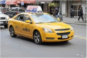
With a total of over twelve thousand taxicabs operating in Manhattan, travel to and from this neighborhood only requires a single street hail to an off-duty taxicab driver. The initial fare begins at $2.50, and increase according to the time of day, the total mileage driven, and total time spent in traffic. A typical taxicab can legally seat three passengers in the back row, and one in the front. This offers commuters opportunities to “split the fare” with other riders traveling in the same direction, thereby significantly reducing individual cab fare. Recently, traditional Ford Crown Victoria taxicabs have been replaced with electric-hybrid vehicles, including the Ford Escape, Toyota Prius, and Volkswagen Jetta TDI, in an effort to reduce carbon emissions in response to increased pollution. These vehicles also offer new technologies, including a credit card system to expand methods of payment, a GPS navigation system to offer passengers information regarding their location, and flat screen monitors for television entertainment.
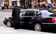
There are several limousine, car and car rental services available within Morningside Heights. In particular, private car services can be attained on 121st Street at Broadway Car Service Inc. between Amsterdam and Broadway Avenue, the Charisma Limousine Service located on Amsterdam Avenue, and many locations along 125th Street. Furthermore, car service need not be located within Morningside Heights, as Manhattan alone offers hundreds of different car service options that can be found in business directories and accessed by a phone call. The price range for these services depend on the type of vehicle, and similar to the taxicab, the distance of travel and the time of travel. These car services tend to be more expensive than taxicabs, given their convenience in that the car service comes directly to the commuter, whereas the commuter would need to find a taxicab for service.
Pedestrians and Bicycles
The number of individuals that are using their bicycles as a mean of transportation has increased in overall in New York City. Along the edges east and west of Morningside Heights, two bicycle lanes have been established that allow cycling access into this neighborhood. There is a single off-street greenway path running along the Hudson River that is approximately 8 feet wide and runs from 116th to 125th Street. An on-street bike lane along Frederick Douglass Boulevard that is 5 feet wide, and in some cases reducing to 4 feet, facilitates access to this neighborhood from Lower Manhattan.
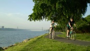
A high volume of cyclists are observed in the Frederick Douglass Boulevard bicycle lane. About 15 to 32 cyclists average in the morning peak hour, 19 to 27 in the midday peak hour and 26 to 36 cyclists in the evening peak hour. The bicycle volume on the Hudson River Greenway average a volume of 58 cyclist per peak hour. However, these numbers are significantly lower the bicycle volumes in Upper and Lower Manhattan where the numbers average up to 200.
Cycling along with walking have accounted to up to 23% of all means of travel in the city. By 2000, New York City had the biggest walking commuters in all American cities by proportion and total number. Due to the lack of a bicycle path network within the neighborhood to access prominent institutions, proposals have been sent to City Council from bikers requesting safe cycling lanes in areas such as Broadway and Amsterdam Avenue.
The number of pedestrians in the Morningside Heights area varies considerably depending on the location. The sidewalks closer to subway stations and bus stops have generally more pedestrian volume. This is also affected by the large residential developments, major institutions, and commercial/retail activity. 125th St and St Nicholas Avenue, Broadway and 116th Street are two intersections that posses the highest volume of pedestrians in the area.
Infrastructure
Movement across this neighborhood in Upper West Manhattan is facilitated by public transit and an arterial-like network of vehicular streets and pedestrian sidewalks. The traffic density within roads and sidewalks is largely determined by the location of important institutions. Many adjustments to the transportation grid have been made and will continue being proposed in order to accommodate changes in travel patterns.
Sidewalks
The width of sidewalks along avenues within this region, ranging from 20 to 25 feet, tend to be unusually wider than other parts of Manhattan, where sidewalks are typically less than 20 feet wide. Along streets, the width of sidewalks average 13 to 15 feet in width, which is typical for a city neighborhood in Manhattan, but there are some exceptions including 122nd Street, which is 19 feet wide, and 116th street between Amsterdam Avenue and Morningside Drive, which is abnormally
Although commuter density along sidewalks varies according to time and various circumstances, the major corridors of pedestrian traffic include 125th Street, 116th Street, Broadway Avenue, Amsterdam Avenue. Studies have been conducted by the NYC Department of City Planning, which measured the number of pedestrians along sidewalks during 15-minute intervals.
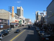
125th Street is a large commercial center for a variety of businesses including retail chains, clothing stores, fast food restaurants, and pharmacies. This street is also easily accessible by a number of bus and subway stations. This attracts a large volume of pedestrians and street vendors, accounting for an average of 100-300 person present in a 15-minute interval during peak periods.

116th Street, bisecting Broadway and Amsterdam Avenue, contains a dense flow of pedestrians during peak hours on weekdays. This is attributed to its proximity to important institutions, including Columbia University, Barnard College, and St. Lukes Hopsital. During a 15-minute interval the number of pedestrians on 116th Street and Amsterdam Avenue was 384, while the volume of foot traffic on 116th Street and Broadway totaled 889 pedestrians.
Roads
The organization of street networks within Morningside Heights makes this neighborhood easily accessible to vehicular transport. With 125th Street, a major road that connects the FDR Drive on the east with the Henry Hudson Parkway on the west, bordering the north of this region, expedited entry is provided into this area from other parts of Manhattan. 125th Street is four lanes wide, with two separate lanes for parking and one moving lane on each side, and 60 feet wide, making it suitable for bus transit and large traffic volume. Broadway, an even larger road 8 lanes wide, with 3 moving lanes left and right, and two opposing parking lanes, allows a large flow of vehicular transport into the heart of the neighborhood, bypassing prominent educational and religious institutions along the avenue.
Traffic volumes vary by location and time, but the greatest surge in traffic is witnessed along major streets, including 125th Street, Broadway Avenue, and Amsterdam Avenue. In these regions, the volume of vehicular traffic along the street per hour ranges from approximately 495-786 vehicles per hour. The local streets situated further from the main social institutions experience lower traffic volume with distance.
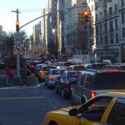
Vehicular speed is affected by several factors including movement of buses, trucks, and pedestrians, traffic conflicts, and illegal parking. Travel speeds in the region typically range from about 10 to 27 miles per hour. The street lane with the lowest travel speed is 125th Street, averaging a steady 10 to 14 miles an hour even during rush hours. The speeds along Broadway Avenue however are typically higher, ranging from 18 to 25 miles per hour, possibly due to the greater number of lanes, fewer buses, and smaller shopping district.
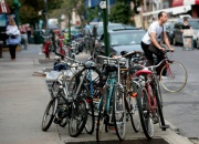
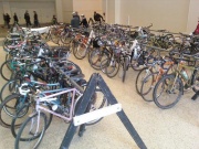
Bicycles, convenient mode of transport, are a prominent mode of vehicular transportation along streets in Morningside Heights. However, cyclists resort to biking either on sidewalks or on the streets in the direction of incoming traffic due to the lack of bicycle lanes. Still, there exists a number of bicycle racks in the neighborhood, even offered by a few restaurants that cater to cyclists. The increasing population of cyclists underscore the necessity of bicycle lanes in the future to improve safety of the cyclists.
Parking
The area is relatively well accommodated for vehicular parking, equipped with access to off-street public or accessory parking, and typical on-street parking.
Off-street public parking includes parking lots that are open for a fee, some privately owned while others are run by the NYC Department of Consumer Affairs. These parking lots are open for use during the day, and some allow vehicles to be parked overnight. Off-street accessory parking includes private parking locations, typically used for commercial parking, residential use, and government or institutional use. The New York City Housing Authority own a few residential parking lots in the region.
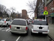
On-street parking is available throughout the region, and is subject to parking restrictions including metered-parking, time restrictions, no parking areas, no standing zones, bus stops, and fire hydrants. Being that 125th Street generally possesses the highest traffic volume in the neighborhood, it contains fewer restrictions than typical streets, allowing more parking to ease traffic congestion. Even with this leeway, reports have shown that 125th street has had a relatively large number of double-parked vehicles, mainly because these vehicles stop to make a quick stop to the store in order to avoid paying meters. Frequently, these drivers end up receiving parking violations and paying fines.
Future Projects
Proposed Bicycle Lanes and Routes
Development of future bicycle lanes and greenways can further encourage New Yorkers to commute through their bicycles. An increasing effort have been seen in order the implement these facilities to combat pollution. Several streets in Morningside Heights have been considered for the expansion of these bicycle lanes and routes. They include 124th St, Riverside Drive, Morningside Drive and Convent Avenue.
New York City Department of City Planning recently proposed the Bicycle Parking Text Amendment in an endeavor to promote cycling among commuters traveling by car. Recently, this proposal has been adopted by the NYC Council. This act generally expand the availability of indoor parking spots for cyclists in the city. Bicycle racks will be installed in residential homes, at job locations, in commercial buildings, and public parking garages.
References
1. http://www.mta.info/nyct/service/schemain.htm
2. http://www.mta.info/nyct/service/bus/bussch.htm
3. http://nyctmc.org/xmanhattan.asp
4. http://www.nyc.gov/html/dcp/html/waterfront/index.shtml
