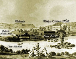
Saw Mill River/Yonkers
From Science and Technology: Baruch IDC 3002H
Contents |
Saw Mill River Bioblitz
What is the Bioblitz?
• Bioblitz is a field study where a group of scientists and volunteers participate in a 24-hour, with the purpose of identifying and recording all the species of a particular group of organisms in a certain area.
• A full Bioblitz must take place over a full 24-hour period, as different organisms are most likely to be found at different times of the day.
• The two main goals of a bioblitz are to:
    (1) Establish the extent of biodiversity in an area

    (2) To help popularize science by getting the public involved.
• At the bioblitz, scientists (such as botanists, mycologists and entomologists) establish a base at a point close to the area they are surveying. The scientists then provide expertise in identifying organisms found by the public as well as doing their own inspection of the area.
Purpose of the Saw Mill River BioBlitz
•To collect data from the Saw Mill River area to inform the public and agencies and help in protecting and improving the wildlife living in the Saw Mill Watershed.
•The sites we visited include following sites:
     (1) Graham Hills County Park

     (2) Con Edison Power Line Cut

     (3) Dobbs Ferry March

     (4) East Rumbrook Park

     (5) Pinecliff Sanctuary
Our Role in the Bigger Picture
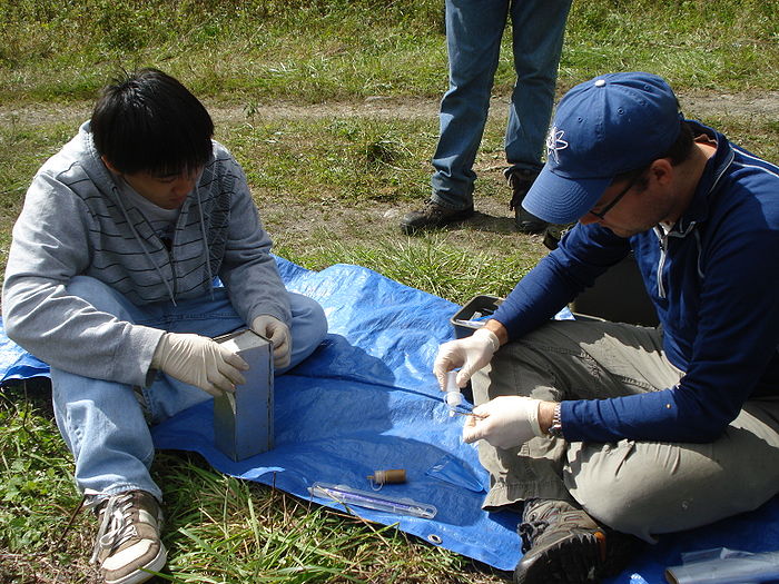
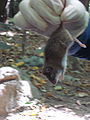
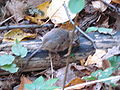
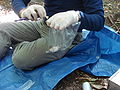
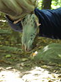
• We documented the mammals inhabiting the Saw Mill River area by making visual observations and setting live traps
• After trapping mammals we took samples by clipping a small portion of the tails of several white-footed mice. These samples are going towards genetic studying the effects of the environment on genetics.
How we laid the traps
(a) Unfold the traps

(b) Insert some birdseed into the traps in order to lure mammals

(c) Also include a small piece of cotton to keep small mammals warm

(d) Keep the opening of the traps open. Once a mammal enters, it will trigger the trap.

(e) Leave traps in areas with possible mammal activity

(f)Leave a visible flag planted next to the traps for to locate them
Geography
Historical Geography
Four hundred million years ago, there were massive mountains located where New York City stands today. Over hundreds of millions of years, the mountains began to erode, leaving boulders and rocky out-crops of gneiss, marble and schist. During the age of glaciations and the Wisconsin Glacial Episode, which was the last major advance of continental glaciers in North America, the Wisconsin ice sheet moved southward at the rate of one foot per day, deepening the bed of the Hudson River and covering what is now Manhattan and the Bronx (Klinger, Day, Bloomberg). Because most of the earth’s water supply was trapped in the glaciers, the sea level was lowered by several hundred feet. Mastodons, woolly mammoths, saber-toothed tigers, and the giant sloth were able to walk across a dry Long Island Sound from Queens to Connecticut.
Overview of Geography
Westchester County shares its border with New York City. It is bordered on the west by the Hudson River and on the east by the Long Island Sound. The landscape is largely rolling hills and is intersected by three main streams, the Croton, Bronx, and Saw Mill River. Tidal mud flats, marshes and sand beaches are spread across the coast (there are artificially maintained beaches on the coast as well).
The rocks of Westchester County consist mainly of many varieties of gneiss, micaschist, and white crystalline limestone with thin interlying beds of serpentine. There are some sandstone and a black diabese besides extensive layers of limestone, gneisses, and schist, which extend across the region occupied by New York City. Where there is limestone or sandstone in this area, the land is usually low, while highlands occur where the hard gneiss comes to the surface near the seashore.
The landscape is largely rolling hills and is intersected by three main streams, the Croton, Bronx, and Saw Mill Rivers. The county is one of the most heavily forested in New York State. It has retained much of its rural characteristics while still adopting an urban and suburban lifestyle as a result of its proximity to New York City.
History of Westchester
Inhabitants of Westchester
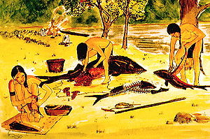
Before the European settlers came to Westchester, it was inhabited by the Native Americans. The Wechquaescheck tribe particularly inhabited the Saw Mill River Valley while the Algonkian tribes lived in other parts of Westchester. These Native Americans were generally more peace loving than the fierce Iroquois, who lived in northern New York. The Algonquian-speaking Lenape Indians called the Hudson River in Yonkers, “Nappeckamack”. Nappeckamack meant "trap fishing place" and was named this because the River was a great place to trap fish. The Native Americans used the area between the Saw Mill River and the Hudson as a fishing, shell collecting and farming area because the land was so well equipped for these activities. They hunted and fished, and grew crops of corn, beans, and pumpkins. They spent the summers on the shores of the Long Island Sound and Hudson River, and moved inland during the colder months. They gathered oysters and other shellfish in summer to be smoked and dried to add to their winter food supply.
The seventeenth-century explorers and settlers found described the Indians they saw as well proportioned and as "sprightly and active". They had straight black hair and dark eyes. The Indians had strong physical build and were rarely deformed or sick.
Saw Mill River Facts
The Saw Mill River was originally named Nepperhan by the Native Americans. Nepperhan stood for "rapid little stream". Presently, the Saw Mill River received its name from the sawmill that was built near its mouth in the mid-1600s. This began the industrialization of Yonkers and the decline of Saw Mill River.
The river begins as a 1.75 acre pond in Chappaqua and it empties into the Hudson in downtown Yonkers. The land is used as industrial, commercial, residential and parkland. The quality of the land is drastically declining due to the influence of these land uses. As you travel south of the river, you can see the decline in quality. The river in New Castle is considered relatively healthy. In New Castle, the plants filter pollutants and provide tree canopy that keeps the water cool and rich in oxygen. However, the Saw Mill River in Central Yonkers is designed for urban flood protection and provides few environmental functions. A USGS study in the early 1990s found that the Saw Mill River at Yonkers has among the worst concentrations of metals in stream-bottom sediment nationwide. Other challenges that the Saw Mill River faces is the invasive species that inhabit the area. These invasive species include bittersweet, multiflora, mugwort, knotweed and porcelain berry.
Reconciling the Demands of Nature
Reconciliation Ecology
As humans continue to urbanize, we do so at the expense of nature. The floral and faunal species currently occupying the land are disrupted and may take years if they ever recover. Reconciliation ecology says we still have time to save most of the world's species. According to Michael Rosenzweig, an ecologist at the University of Arizona, simply protecting wildlife is not enough to preserve biodiversity due to the need for a large area so support such a wide range of species. Therefore to protect diversity, we must remake our urbanizing society so that it can support both humans and other species.
Endangered Species in Westchester County
As the Westchester area developed from the predominantly agrarian societies of the 1600 and 1700s, they began to disrupt the native populations that inhabited the area. Significant infrastructure improvements during this time included the Croton Dam and Aqueduct from 1837-1842, and the New York and Harlem railroads in the 1840s. Subsequent developments transformed in Westchester County from a rural area into the suburban area that is known today. Shopping centers, single family houses, and massive corporate headquarters and office facilities were built, bring certain species, such as the Eastern Wolf, and the endangerment of many other species.
Westchester 2025
Acknowledging the long-term ecological implications of rapid growth, Westchester County developed Westchester 2025, a document that governs developmental projects in a way that balances economic and environment concerns while encouraging sustainable growth.
Open Space Policy
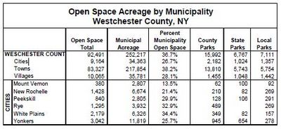
Open space in Westchester, as defined by the municipal government, is meant to protect biodiversity corridors for the welfare and preservation of wildlife. These spaces include undeveloped land, recreational areas, and unique property that require protection.
City planners in the early 1900s saw the need for preservation. This clairvoyance allowed Westchester to make strategic land acquisitions, such as the Bronx River Parkway to establish open space corridors. The Bronx River Parkway currently links city centers, county facilities, and parks.
The establishment of these conservations serve not only to protect the native plant and animal species, but also serves as relief for the inhabitants of the densely populated urban and suburban areas, looking for some relief.
Development of Saw Mill
Decisions in Development
The Dutch discovered that the Saw Mill River area was fertile in 1609. Henry Hudson and his crew even got oysters from the Native Americans. In 1642 a Dutchman named Adriaen van der Donck purchased the land from the Native Americans and built a Saw Mill.
In the 1700’s the area had waterfalls that powered the sawmills so it became an industrialized downtown. The dams were demolished in 1893 because the citizens of Yonkers were concerned by the pollution. In the early 20th century, the construction of the Saw Mill River Parkway, the New York State Thruway, and other roads altered the river’s course.
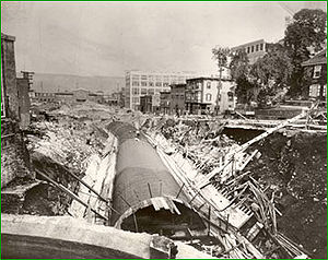
A subterranean flume was constructed in 1917, plummeting the Saw Mill River half a mile underground underneath Getty Square, North Broadway, and Larkin Plaza, so the river could empty into the Hudson just north of Yonkers.
In 2005, Groundwork Yonkers and Scenic Hudson held three meetings with members of the community to teach about ideas to bring the Saw Mill River to daylight.
Today, there is a day lighting campaign to bring the Saw River Mill up from underground, which has implications to positively impact Yonkers and the Saw Mill River socially, economically, culturally, and environmentally.
Deer Management
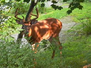
Deer Overabundance in Suburban Areas
White-tailed deer populations within the United States have undergone tremendous change within the past two centuries. How?
(1)Natural habitat succession, deer restoration programs, intensive management efforts, predator control programs, public education campaigns, and the deer’s natural adaptive abilities have all contributed to historic high deer densities across the United States. (2)As citizens increasingly seek refuge from urban life, they create a demand for residential areas that incorporate elements of the land’s natural surroundings. These natural habitat features commonly include patches or mosaics of undeveloped habitat utilized for visual obstruction, recreational areas, or erosion control. This highly fragmented landscape is the preferred habitat structure of white-tailed deer. Residential developments also possess a variety of planted trees and shrubs, and large portions of the landscape are watered and fertilized. In many cases, the nutritional quality of the food is not as high as that in rural areas, but the quantity of food is high. Thus, this enhanced landscape provides year-around stable living conditions for deer, as opposed to fluctuations in forage availability on natural ranges. (3)Scarcity of predators within these habitats. Modern deer populations on natural ranges are maintained at suitable levels largely by fawn predation. The reduction of predators within less natural, suburban habitats contributes to unusually high fawn survival rates.
Deer management is certainly not an easy task. Many factors, some named above, must be taken into consideration when approaching the problematic situation of deer overpopulation. However, managing an overabundant deer population can and should be accomplished in two phases. First, the Initial Reduction Phase is implemented to remove large numbers of deer from an overabundant herd during a short period of time to achieve desired deer densities. After completion of the initial phase, a Maintenance Phase includes long-term efforts to maintain deer densities at target levels. Many protected areas include deer-proof fencing projects in their long-term maintenance program in order to restrict the ingress of additional deer and gain more control over their deer herd. Other preventative measures have been taken in order to restrict the growing, unchecked deer population. In which, you can design a landscape with only deer-resistant plants is an effective solution for dealing with potential deer damage. Most homeowners select this method because it adds no additional cost or maintenance. The risk is minimal. Other methods call for a change in the type of plants that are planted in residential suburban gardens. For instance, change from White Pine to the Japanese Black Pine, from the Yew to the Boxwood, from Tulips to Daffodils, from Geranium to Moonbeam Coreopsis, or from the English Ivy to the Pachysandra.
Implications of Deer Overabundance
(1) Deer/Vehicle Collisions
(2) Lyme Disease
(3) Landscape/Garden Damage
(4) Habitat Degradation
(5) Declining Deer Herd Health
Saw Mill Mammal Trapping Adventures
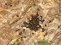 Deer Poop |
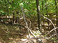 Site 1 |
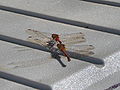 Dragonflies Mating |
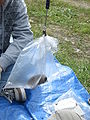
 Releasing Mouse Back into Wild |
 White Footed Mouse |
 Paralyzed White Footed Mouse |
 Measuring the White Footed Mouse |
 YUM |
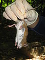 White Footed Mouse CAUGHT |
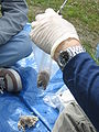 Weighing the Mouse |
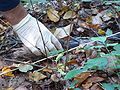
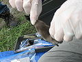 Preparing to cut the mouse's tail |
 Weighing |
Citations
1. Christie. R. 2002. Benthic Macroinvertebrate Analysis for the Saw Mill River, Westchester County, NY. Report. NYS DEC. Westchester County, NY.
(The quality of Saw Mill River and the different types of fauna and benthis macrinvertebrate inhabiting the river.)
2. Day, L.; Bloomberg M.; Klingler M.A. 2007. Field Guide to the Natural World of New York. The Johns Hopkins University Press, Baltimore, MD.
(The history of NYC's ecology, the different species that live in the parks of each borough and the human history of these parks.)
3. Hudenko, Hudenko W.; and Siemer, William F. 2008. Humans and Coyotes in Suburbia: Can Experience Lead to Sustainable Coexistence?, Ithaca, New York. Human Dimensions Research Unit. Series No. 08-9
(Study of Westchester County’s occupation of coyotes.)
4. Hudenko. Heather W.; and Siemer, William F. 2008. Living with Coyotes in Suburban areas: Insights from Two New York State Counties, Ithaca, New York. Human Dimensions Research Unit. Series No. 08-8
(The effect of coyote’s occupation in human habitat.)
5. Shaw. J.S. 2004. Suburban Development Benefits Wildlife. Environment & Climate News. The Heartland Institute. Chicago, IL.
(Discuss the fact that natural reforestation increases the population of animals in certain areas and the effects of human migration to rural areas thereby changing the natural landscape.)
6. Feldhamer, G.; Thompson, B.; Chapman, J. 2003. Wild Mammals of North America. The Johns Hopkins University Press. Baltimore, MD.
(Discusses the different mammal species in the New York area and also discusses mammal trappings.)
7. Shonnard, F.; Spooner, W. 1900. History of Westchester County, NY: from its earliest settlement to the year 1990, Part 1. New York History Co., 1900: Westchester County, NY.
(A 638-page book discussing the history of Westchester County up until 1900s.)
8. Bronx Valley Sewer Commission. 1896. The Final Report of the Bronx River Valley Sewer Commission, Westchester County Archives. Available at <http://www.westchesterarchives.com/HT/muni/wca/brvs.html>
(A 1896 report from the sewer commission reporting their findings at the Bronx River valley.)
9. Crimmens, T.; Bronx River Alliance Marit Larson; City of New York Parks & Recreation; Natural Resources Group. 2006. Bronx River Ecological Restoration and Management Plan. Bronx River Alliance: Bronx, NY.
(The Bronx River Alliance’s approach at restoring wildlife habitat and water quality in the Bronx River)
10. Curtis, Paul D.; and Sullivan, Kristi L., Wildlife Damage Management Fact Sheet Series: Raccoons; Cornell Cooperative Extension, Wildlife Damage Management Program, 2001 Cornell University.
(The Cornell University Research paper about population reduction in raccoons as well as the laws and regulation enacted to protect the raccoon population.)
http://www.fws.gov/northeast/nyfo/es/CountyLists/WestchesterDec2006.htm
http://www.westchestergov.com/planning/research/Databook/History_Geog_LU.pdf
http://www.co.westchester.ny.us/parks/NatureCenters05/EndangeredSpecies/AmphibiansReptilesMammals.htm
http://www.pace.edu/page.cfm?doc_id=24089
