|
|
Let's Go For A WalkFrom The Peopling of New York City
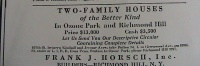
Let's Go For a Walk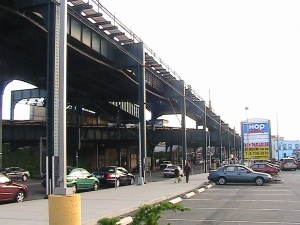 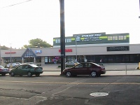 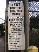 To your right, you will see a small complex of stores just opened this past summer '08 in what used to be an abandoned lot. The buildings included in this small complex are IHOP, 99 Paradise, Storage Post, and Chemistry Lounge – the only building that has yet to be completed and opened to the public. To the left is a brick building that you will probably imagine is abandoned at first glance due to its lack of a sign and the weeded parking lot. Turning to the exit of the lot, however, which faces the other side of the street with the small complex, three small signs are apparent. The top sign reads, “N.Y.C.T. Liberty JCT. Signal/R.T.O Facility.” The sign resting below it reads, “Liberty Junction Restricted Parking Limited To: Tower & Signal Employees Working At This Location Only.” The last sign reads, “Pursuant To: MTA/NYCT Policty/Instruction 1.7.1 of 10/30/00 Enforcement: MTA/NYCT Policy/Instuction 1.7.1 Sec. 6.3 Sub. 6.3.5.” [1] Grounds for DiscoveryAt this point, we can conclude with certainty that a collision of time exists on this block: the age-bearing train tracks connected to an old brick building against the up-to-date complex of popular sites. We could assume with tangible proof that the train perhaps isn’t very old either because of that one date we stumbled upon through the sign, which confirms that the train has been there a minimum of 9 years thus far. An article in the New York Times, however, refers to the presence of these railroad tracks as far back as 1947, when the writer Jack Kerouac boarded the train to go into Manhattan. The article suggests that the A train itself never actually entered Ozone Park, and fails to properly name the train car that the writer boards before transferring onto the A line. After reading this article, however, I automatically thought of the late night schedule that the Lefferts Boulevard A train follows. This schedule consists of a shuttle train between the A train’s usual last stop, Lefferts Boulevard, and the splitting point of the two A trains, Rockaway Boulevard. It seems as though this shuttle may have once extended into Brooklyn before it was deemed for short-lived nighttime travel only. [2] Preliminary conclusions regarding the buildings on this block can also be made. As already stated, the small complex is an extremely recent addition to Ozone Park. It was still a lot only two years ago in 2007. This lot, however, could not have possibly existed for a long time. Another article from the New York Times includes clips from local residents during the year 1984, one person stating that there were rarely any lots open for building and, consequently, building was rather rare to its residents. This holds true to today, where my focal point for research exists as one of the few areas in this neighborhood that has undergone such recent change – the elevation of places that even tourists will find familiar. [3] So many questions begin to emerge at the end of this preliminary research. When did the tracks actually go up, and, furthermore, when was the A line extended into Ozone Park as it exists today? What existed in that lot before the popularized IHOP and future-inspired Chemistry Lounge settled in? Did the sudden change of immigrant population within this block, and the neighborhood in general, occur for similar reasons to why my family moved to Ozone Park – the remodeling and dramatic increases in housing elsewhere? After visiting the local community library right off Liberty Avenue on Lefferts Boulevard, nothing other than the action of obtaining a library card could be accomplished due to the fact that this library is small and consists of no archives. With that being said, our journey will continue further with the next destination: the Queens Public Library on Merrick Boulevard, which does house archives and therefore should prove most helpful in answering, or at least probing into, most if not all of these questions. A New Day Rich With ProgressHaving no primary, truly reliable resources, I scheduled a visit to the Queens Public Library in Jamaica, Queens on a rainy Saturday in hope of gaining insight on the deeper past of my street. To my relief, the research material I came upon had no reflections on the damp and gray day that existed outside. I was given many items to delve into: a book with the history of street names in Queens, a folder of street name changes in Queens, and a folder filled with articles related to the history of Ozone Park, bound together between the covers of a book. To my disappointment, the first two sources had no information regarding Liberty Avenue. The third, however, gave me all of the information I was hoping for, and more. An additional visit to the Municipal Archives on Chamber Street, though not as successful, also proved helpful in providing images of Ozone Park as it existed in its earlier history. Ozone Park: A Brief HistoryOzone Park is indeed a unique neighborhood – it has not only escaped industrial expansion, unlike other New York City neighborhoods, but has also been around for a much shorter time than other New York City neighborhoods. It can therefore be described as a young, unchanging – and, consequently, nostalgic – world of its own. Approaching its 129th year of existence, Ozone Park remains an area of residential comfort with industrial benefits. However, let me present to you a short history of this area, zooming in afterwards on the development of Liberty Avenue, one of the most industrious parts of Ozone Park. From Scarce Farmland to Boisterous Industry During the 19th century, what we now know as Ozone Park was nothing more than stretches of farmland under the care of a few owners – typical colonization. Life was laidback – at least opposed to modern-day city life – and the soil was rich for planting corn, potatoes, and tomatoes [5]. I can verify that the same holds true for today, at least with regards to tomatoes – as a resident of Ozone Park with my family, our yard produces plenty every summer. The farm owners who are most commonly recalled in this area’s history include Mr. Napier, Stephen H. Lott, Stephen I. Lott, E. Van Wicklen, and Alfred McCormick [6]. With a lens prying into the specific history of Liberty Avenue, near its intersection with Rockaway Boulevard, I found the two farmers E. Van Wicklen and Alfred McCormick to prove most beneficial in uncovering some history on my street. Specific details found on these two men and their property with relation to locations today can be seen below, under Historical Profiles.
 In the year 1880, Benjamin W. Hitchcock and Charles C. Denton, two real estate developers, purchased much of the farmland and divided it into lots. Hitchcock called the area Ozone Park after the breeze that swept over the farmland from Jamaica Bay and the Atlantic Ocean [8]. In addition to Hitchcock and Denton purchasing and preparing blueprints for the land, transportation was also established in the area as the New York, Woodhaven, and Rockaway Railroad extended its services from Long Island City to both Howard Beach and Rockaway Beach [9]. By 1883, the land slowly became populated by both businesses and residents due to its country-like feel compared to the city life in Manhattan, which was but a few train stops away [10]. A specific profile on Benjamin W. Hitchcock can be seen below, under Historical Profiles. Liberty Avenue: The Artery of Ozone Park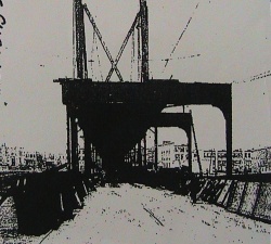 It is best to introduce Liberty Avenue at this point of Ozone Park’s history because of the great amount it contributes to the development of the neighborhood. I never managed to come across a specific “birth date” for Liberty Avenue, even when scouring through the internet for starting points that would assist me at the archives. It is evident, however, that this street existed as far back as 1870, indeed preceding the actual birth of its current residency today. It was known for its Toll Gate, where drivers paid three cents per mile. The receipts from the toll were used to repair the roads and keep them in an acceptable state for the purpose of transportation [12].  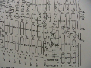 By 1925, three stops of the new “El” train – Rockaway Boulevard, 104th Street, and 111th Street – were elevated [16]. With an elevated train line providing a quick route to other boroughs, the empty land which it shadowed was rapidly developed and dramatically increased in value. Stores sprung up along either side of the elevated tracks and Ozone Park became more popular not only as a place for commercialization, but residence as well [17]. Population skyrocketed from roughly 20,000 people in 1920 to 39,990 people upon the arrival of 1930, leading to an estimated construction of about 4,837 new homes as early as 1927 [18]. Popularization of the area earned Liberty Avenue a makeover from Rockaway Boulevard to Lefferts Boulevard – streets graded, given sewers, and eventually paved with asphalt as well [19]. Clearly, the 1920s were a time of “industrial boom” in Ozone Park, due in great part to this street alone. Historical ProfilesAlthough I attempted to find more elaborate historical profiles on E. Van Wicklen, Alfred McCormick, and Benjamin W. Hitchcock, such proved difficult at both the Queens Public Library and the Municipal Archives. For this reason, I’ve decided to present the bit of information that I uncovered on all three historical figures in one, separate section to avoid straying away from the overall history of Ozone Park. E. Van Wicklen & Alfred McCormickE. Van Wicklen and Alfred McCormick are the two farm owners whose farmland fell within the boundaries of my specific street. Wicklen’s property included 103rd Avenue to Rockaway Boulevard, as well as land east to 96th Street. McCormick’s property stretched out along 97th Street towards Liberty Avenue, as well as east to Ocean Avenue and north to 101st Avenue [20]. Further research on Alfred McCormick proved unsuccessful. Contrarily, while the specific name E. Van Wicklen, too, was unsuccessful in research, some information was found on multiple Van Wicklen families during the 19th Century in present-day Queens. A John Van Wicklen House appeared on a deed on January 2, 1837, located partly on Rockaway Boulevard. A Lott Van Wicklen House existed partly on Woodhaven Boulevard and was referred to as the Mrs. M. Van Wicklen House by 1860. One last Lott Van Wicklen Dutch farmhouse was also located partly on Woodhaven Boulevard, 350 feet south of Liberty Avenue. Although it is not exact which of these three families is the one which has associations with E. Van Wicklen, it is safe for one to expect either the first or last to be the best choices due to the first family’s location and the second family’s residence in a farmhouse, since E. Van Wicklen was indeed a farm owner. [21] Benjamin W. HitchcockWithin the context of Ozone Park’s history, Benjamin W. Hitchcock is the one of the two real estate developers that primarily worked on the lot arrangement, and naming, of Ozone Park. Further research revealed that Hitchcock was not only a real estate developer, but a music publisher as well [22], owning retail music shop on the corner of Ann Street and Nassau Street in Manhattan. He resided on the Westside of Main Street, Flushing. Additional examples of his projects as a real estate developer include the development of Hitchcock Park (present-day Flushing Park) and Corona in 1872 [23] . Interesting Discoveries Along the WayThis section is designated for two small but interesting historical discoveries I came across during my research at the Queens Public Library that do not fall smoothly in the history of my street, but are indeed related to the area. Because they are only related to the area and do not formally contribute to my research, they will only be mentioned briefly. The Clark HomesteadAlthough this interesting historical event did not occur on the specific location I focused on – Liberty Avenue between 98th and 99th Streets – it did occur along Liberty Avenue at its intersection with Cross Bay Boulevard. On this corner, where a theater is now located, once stood the Clark Homestead, build in the 1700s. According to Queens Borough Public Library records, the homestead acted as a temporary place of residence for George Washington during the Revolutionary War. [24] Negro Cemetary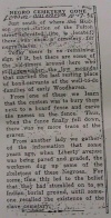 This particular discovery was most interesting to me because this past semester, our class visited the part of Manhattan that was once a Negro Burial Ground. According to a document I came across at the library’s archives, a cemetery for negro slaves once existed just south of the 80th Street-Hudson Street stop on the A train. According to unnamed sources, the slaves were buried beside a board fence, where the bodies' names were engraved. Once this fence was taken down, however, the cemetery was forgotten. Further information reveals that during the grading and pavement of Liberty Avenue, human bones were unearthed. While the bones were first believed to be the bones of Native American tribes that preceded European colonization, locals revealed that the area was a cemetery for slaves, thus confirming the bones to be those of slaves. [26] The Peopling of New York – A Neighborhood As Diverse As the City Itself: ConclusionThe population of Ozone Park was, for the most part, made up of Italians and Polos [27]. Today, however, one will not be surprised to see a great number of Hispanics, African Americans, and Asians – not only in the neighborhood as a whole, but mixed along one block of houses as well. It is without a doubt that the rural-styled neighborhood and convenient means of transportation are the two key attractions which brought such a diverse group of people within the same, small area. In that sense, it is evident that Liberty Avenue has played a major role in the development not only of a neighborhood, but of cultural center as well. Throughout the semester, the topic of how diverse New York really is has always come up again and again. At a certain point, we agreed that New York is not as diverse as people and books may boast that it is. After doing my research, however, and just from my experience as a resident of Ozone Park that constantly takes strolls down Liberty Avenue to go just about anywhere, I can confidently speak against this claim – for this neighborhood, at least. Why does such a diverse group of people live so peacefully here? It is already safe to assume that those who reside here came here due to its quiet residential areas and 24/7 commercial areas. Having public transportation right at one’s fingertips is a nice bonus, too. Perhaps it is the great contrasts that exist between the industrial and the rural despite their close proximities to one another that really attracts the public. After all, it is very convenient to live peacefully on a quiet block and then be able to walk just one block more to Liberty Avenue and find countless stores still open, even when the sun ceases to shine. It may also be the neighborhood’s resistance to change in its residential areas that attracts people to come and reside here as well. Who wouldn’t want to walk down the block and see images from their childhood as though it were just yesterday? Overall, people in New York are brought together by a similar cause: to keep a flowing income for a prolific life. Life, however, does not need to revolve around work. For an escape from the ever changing world and the chaotic city life, there is Ozone Park. A neighborhood in a world of its own, connected to the rapid pulse of city life by a single street – one that has served as a resting place for the dead, as a palette for development, and as a path towards the less pleasant aspects of New York City. Returning to the present, you can now look up at the tracks and know that at one point in time, the sun shone upon the ground that you stand on. At one point in time, the buildings around you were replaced by miles and miles of farmland. That breeze which earned this neighborhood its name can no longer flow as smoothly with all the houses that now stand. Our journey here is done. Run to the pulse of the vibrating tracks – catch the train that will take you home. Liberty Avenue
References
|
