From The Peopling of New York City
Cognitive maps gathered from interviewees are often indispensable tools of research. In the course of our research, we asked the people we interviewed -- everyone from real estate agents, to residents, to a college professor -- to construct a cognitive map of Jackson Heights. All of our interviewees were asked very similar questions, which pertained to where the safest areas are in the neighborhood, and to draw any and all significant landmarks in Jackson Heights. The goal of these maps was not to gather 'accurate' outlines of where shops and schools are located: rather, these maps are a physical representation of what the neighborhood means to different people. When examined side-by-side, these can highlight similar trends among businesspeople or residents, for example, in identifying their stores or homes as the center of the neighborhood. Likewise, they can demonstrate how common perceptions of the neighborhood are shaped by representations of Jackson Heights. They also exemplify an important point mentioned in our website -- many of the residents of Jackson Heights live in their own ethnic enclaves, and fail to associate themselves economically, politically, and sometimes even socially with other ethnicities.
Maps by current and former real estate agents:
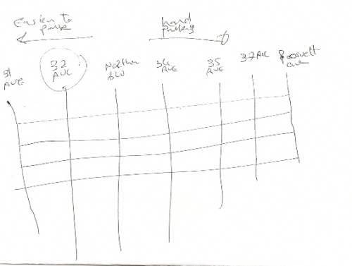
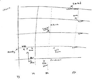
This is the cognitive map of Yassir Aziz Bassily of Prudential Douglas Elliman Real Estate. He views Jackson Heights as a grid, with the center being the Historical District. As a real estate agent and resident of Jackson Heights, he emphasized the increased congestion and the difficulty to find parking as one heads toward Roosevelt Avenue. For him, Jackson Heights starts on 69th Street and ends on 94th Street. Although he resides in Jackson Heights, he did not mention any specific landmarks except the Historical District.
Maps by residents and consumers:
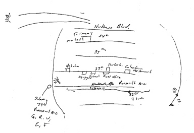
This cognitive map was drawn by a Jackson Heights resident having brunch with his girlfriend in Starbucks. He works in midtown, so he takes the subway 7 line almost daily. On his map he shows the G, R, V, E, and F trains on 74th street, which he rides on occasion as well. In the center of his map, he draws in particular landmarks he associates with in his neighborhood; here he includes an Indian restaurant, a synagogue, an elementary school, a post office, and a Starbucks (to which he goes every day). The couple enjoys the variety in the neighborhood, and when asked if they feel an ethnic divide, they responded, “Divide is probably the wrong word for us.” They do not find, or perhaps do not want to find, conflicts between ethnic or economic groups.
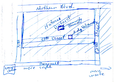
This is the cognitive map of a woman who was sitting in Expresso 77. She chose to only draw a few blocks of Jackson Heights because these are the only blocks she associates with. She boxed her favorite clothing store in the neighborhood, Rudy Volcano, and what she considers to be an important landmark, the Community Methodist Church. As she travels further away from her home on 75th street, she feels more unsafe.
Maps by members of organizations in Jackson Heights:
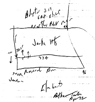
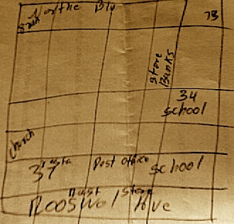
This map is by Arthur Teiler, the Community Board 3 Treasurer. While drawing it, he described how Jackson Heights' northern boundary is traditionally set at Northern Blvd, but a fair amount of people are moving above Northern and still considering themselves as residents of Jackson Heights. Mr. Teiler also spoke about the congestion on 73rd St because this is the only street that goes south in the area.
This is a cognitive map drawn by Omar Rajwani, a parent-coordinator of the school at the United Methodist Church and also an active member of the church for 2 years. From his map, we can see that Omar Rajwani's Jackson Heights is centered around his church. He moved to the neighborhood a couple of months ago to be close to the church, where he and his wife work. He is able to walk to work and to most of the other landmarks in his map. He mentioned that the other reason he moved to Jackson Heights was to experience the cultural diversity - he likes to try new foods and buy little ethnic knick-knacks from the different communities of the neighborhood.
This cognitive map was drawn by Susanna Torres, a Coordinator Administrator of the Community Group. Torres' Jackson Heights is small and confined to a specific area. She marked places that most people would go to - no matter their background or class - such as the church, bank, post office, and school. Additionally, she acknowledged there are different ethnic groups in the neighborhood but she doesn’t emphasize them in her map.